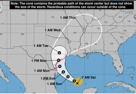
Hurricane trackers are vital tools in meteorology, providing critical data that helps predict the path, intensity, and potential impact of these powerful storms. The science behind hurricane tracking involves a combination of satellite technology, atmospheric models, and real-time data collection.
Satellite Technology
Satellites play a crucial role in hurricane tracking. They provide a bird’s-eye view of storm systems, allowing meteorologists to monitor their development and movement. Modern satellites, such as the GOES (Geostationary Operational Environmental Satellites), offer continuous observation of weather patterns. These satellites are equipped with advanced sensors that capture high-resolution images and measure various atmospheric parameters, including temperature, humidity, and wind speed.
Advanced Instruments: COWVR and TEMPEST
Recent advancements in satellite technology have introduced smaller, more cost-effective instruments like COWVR (Compact Ocean Wind Vector Radiometer) and TEMPEST (Temporal Experiment for Storms and Tropical Systems). These instruments, installed on the International Space Station, provide valuable data on wind speed, direction, and atmospheric water vapor. This information is crucial for understanding storm structure and predicting its path.
Atmospheric Models
Atmospheric models are mathematical simulations that predict the behavior of weather systems. These models use data from satellites, weather stations, and other sources to simulate the atmosphere’s dynamics. The Global Forecast System (GFS) and the European Centre for Medium-Range Weather Forecasts (ECMWF) are two of the most widely used models in hurricane forecasting. They provide predictions on storm intensity, track, and potential landfall locations.
Real-Time Data Collection
In addition to satellite data, real-time observations from weather buoys, aircraft, and radar systems are essential for accurate hurricane tracking. Hurricane Hunter aircraft fly directly into storms to collect data on wind speed, pressure, and temperature. This data is transmitted in real-time to meteorologists, who use it to refine their forecasts.
The Role of the National Hurricane Center
The National Hurricane Center (NHC) is the primary organization responsible for tracking and forecasting hurricanes in the Atlantic and Eastern Pacific regions. The NHC uses data from various sources, including satellites, aircraft, and surface observations, to issue warnings and advisories. Their forecasts help governments and communities prepare for potential impacts, reducing the risk to life and property.
Conclusion
The science behind hurricane trackers is a blend of advanced technology, mathematical modeling, and real-time data collection. These tools and techniques are essential for predicting the behavior of hurricanes and mitigating their impact. As technology continues to evolve, the accuracy and reliability of hurricane tracking will only improve, providing even greater protection for those in the path of these powerful storms.
